

SUMMER SALE! 3 Months for Only 25¢Wherever you go, stay connected with access. Sale Ends July 27 |
We're in the dog days of summer, even if it doesn't really feel like it
Texas is in the throes of the dog days of summer, and we'll be in them for four more weeks. The dog days of summer traditionally has referred to the hottest days of the year, but the days are actually a specific period: July 3 to Aug. 11, when Sirius, the brightest star in the constellation Canis Major ("larger dog" in Latin), rises and falls in conjunction with our sun.
The hottest time of the year in Houston, on average, is between July 29 and Aug. 12, when temperatures normally reach an annual peak of 96 degrees. If the occurrence of 100-degree days is your preferred metric for hottest period, then Houston has recorded triple-digit temperatures, on average, from July 19 to Aug. 17.
However, this summer has been a mixed bag for Houston. Despite recording the city's ninth-warmest June this year, daily high temperatures in July have stayed relatively close to normal, thanks to frequent rainy weather in the first half of the month. Some forecast models, though, suggest we could be warming up to above-normal temperatures in the second half of July.
READ MORE: We're in the dog days of summer. Yes, they're real — here's what they mean for Texas
 | Roberto Villalpando, Texas Weather Science Editor |
Justin's Five Day Fit Check

Photo by: Ken Ellis
For anyone weary of the dog days of summer, take comfort in knowing that we'll put off 100-degree heat another week, thanks to a continued stormy weather pattern. The driest days are likely to be Wednesday and Thursday as high atmospheric pressure builds in briefly. A deep surge of tropical moisture will keep rain chances elevated beginning Friday through the upcoming weekend.
 | Ask a Meteorologist |
Do tropical storms or hurricanes follow a basic timeline for formation and landfall?
This question is especially important this week because the National Hurricane Center is tracking what could become a tropical disturbance in the Gulf of Mexico. A westward-moving system that develops there has virtually no chance of avoiding a landfall along a coastline that stretches from Florida to Texas and then southward to Mexico.
Within only 48 hours, a tropical low pressure system can turn into a named tropical storm quickly in the Gulf of Mexico. That means in only two days, a tropical storm could form and make landfall, bringing wind of at least 39 mph.
If ingredients align for continued strengthening of the tropical storm, a hurricane could form. A tropical storm is classified as a hurricane once storm winds reach 74 mph. Hurricanes can form in just a day or two. For example, Hurricane Ida, which battered the Louisiana Gulf Coast in 2021, took only three days to become a Category 4 storm with winds stronger than 130 mph.
A storm that forms in the Gulf could take only two or three days to make its inevitable landfall on a coast. The expansive Southeast Texas coastline makes it a vulnerable location, so we should closely monitor the forecast this time of year.
READ MORE: Tropical downpours to soak Houston this week as Gulf wakes up. Here's what to know.
Do you have a Houston weather or climate question? If so, you can submit your weather questions to justin.ballard@houstonchronicle.com. They may just end up in a future edition of the weather newsletter.
Something to see
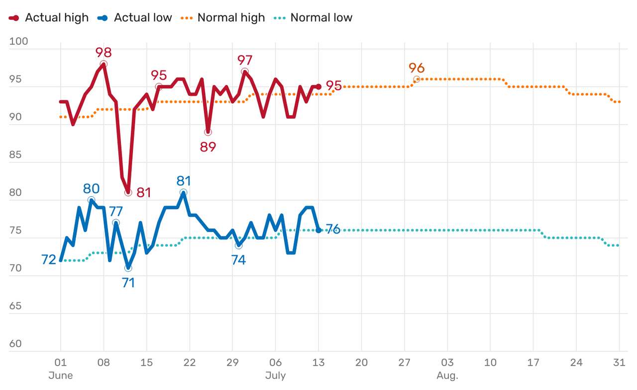
Photo by: National Weather Service
Shown are Houston's daily temperatures for meteorological summer (June, July and August). At the midpoint of the season, the city has so far recorded its ninth-hottest June, which had an average daily temperature of 84.7 degrees, or 1.7 degrees warmer than normal. July's average daily temperature to date is 85.2 degrees, or just a half-degree above normal. Figures are from Bush Intercontinental Airport, Houston's official climate observation site. Normal values are based on averages taken from 30 years of observed data from 1991 to 2020.
Texas Weather Wonks Trivia
Houston has seen plenty of rain in the first half of July. In fact, the city's rainiest single day in July produced 5.43 inches in 2010. What was the date?
A) July 2
B) July 6
C) July 8
D) July 12
Hit reply to this email to let us know what your guess is and a chance to win. We'll let you know who answered correctly first in next week's newsletter.
Here's the correct answer to last week's trivia question: When is the latest July date for Houston to see its first 100-degree day of the year? (Hint: it happened in 1914.) It's C) July 30.
Other weather news
|

|

|

|

|

Meet the Team

Photo by: Susan Barber
The 713 Weather Radar newsletter is written and produced by meteorologist Justin Ballard and Texas Weather Science Editor Roberto Villalpando. You can reach out to them at justin.ballard@houstonchronicle.com and roberto.villalpando@houstonchronicle.com or by replying directly to this email.
|
Unsubscribe | Manage Preferences

Houston Chronicle
4747 Southwest Freeway, Houston, TX 77027
© 2025 Hearst Newspapers, LLC


No comments:
Post a Comment